Welcome to LXN Online
This is a little navigation helper for flying gliders in MSFS. If you read this, you're probably starting to play around with it.
When in doubt, rely on your ingame instruments. Most importantly don't use any information from this web app as a base for results in any online competition.
And of course the usual: this is all just for fun and entertainment. Should you somehow manage to hurt yourself during a simulated glider flight, don't hesitate to complain about it on the internet. I'd love to hear the story, but accept no liability.
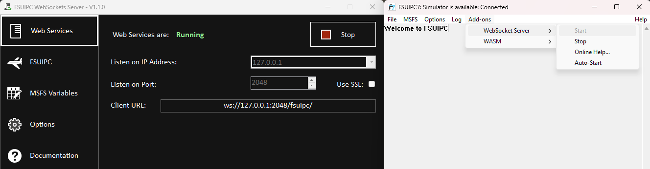
The first and most important thing you need is "FSUIPC" by Pete and John Dowson. A tool that has been around MS Flight Sims for decades and can do a lot of useful things for you. We'll only need it as a connection to get data from the sim. The tool for that is the included "Web Socket Server". Go ahead, download and install the latest version. You won't need a registration, the free version will do just fine.
If you install FSUIPC with the default settings, it will automatically start in the background, when you start MSFS the next time and wait for you in the system tray. If you prefer to start manually you can do so as well.
Open FSUIPC and start the Web Socket Server by going to Add-ons/WebSocket Server/Start. For now don't change anything in there, leave the IP Address at 127.0.0.1 and the port to 2048.
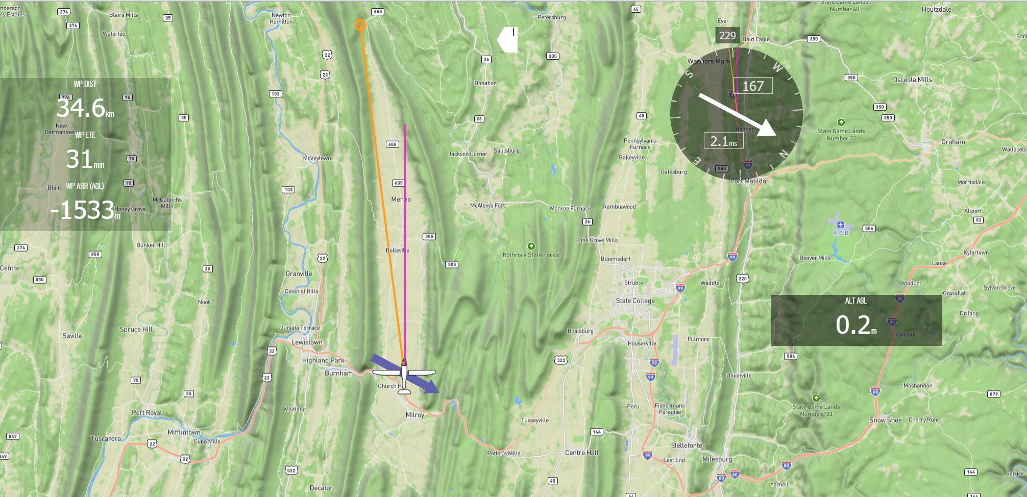
Now start up a flight in MSFS, reload the lxn2 webapp and hit "connect" in the popup window. You should now see your aircraft's position on the map.
If the map is still centered southeast of Hamburg, you have no connection to the socket server. Make sure it is running. If the map is centered off the coast of africa, you established a connection, but receive no data from FS. Make sure, you have started a flight and are sitting in the cockpit.
More information can be found in the debug window on the config/connection tab, which brings us to the
Basic Navigation
When you move the mouse pointer to the bottom of the page, you reveal the nav bar with a couple of buttons. The right side buttons control the map and should be rather self explanatory.
The buttons on the left:
- Task
- Click "File" in the top left to load a usual .pln file. The task status and waypoints will display below and distances and arrival heights will be calculated. Take care though: Task status is not synchronized with the game. Make sure you have "start" as the active waypoint in both the ingame instrument and the webapp when you cross the start line.
- Nav
- Displays a list of markpoints - which is initially empty. Click anywhere on the map to add and name a marker. All markers are listed on the nav page. Click any of them to make them your nav target. The map will now show a yellow line from you aircraft to the marker and all "current waypoint" calculations will be done for that markpoint. "Save" will download all current markpoints as a .json-file, that can be loaded later. The *.json will automatically be named "lxn_markpoints-DATE.json" and be stored in your brwoser's default download folder.
- Config
- "Aircraft" is currently only for info purposes. The drop down contains all currently configured aircraft models that are detected automatically. "Units" lets you switch between metric and imperial units and "Connection" contains info about your current FSUIPC connection state.
This is also the spot to enter the IP-Address of your FSUIPC web socket server, should you decide to use anything else then the default. - Edit
- This is the fun part, as this lets you configure your personal interface
Edit Mode
Clicking "Edit" toggles the app to edit mode and reveals two more buttons: reset and add. "Reset" returns the interface to the default state if anything ever goes really wrong.
"Add" shows even more buttons - a collection of elements that can be added to the interface.
- Datafield
- A data field that can display a selected variable. Simply click the data field to open the editor (more on that later)
- Variometer
- By default shows Total Energy. Click the TE-number top right to switch to to Netto, click the average value to toggle between 5 an 10s averager. Click "Scale" to switch between a normal and a logarithmic scale.
- Course Pointer
- Displays a pointer to the current waypoint. For the first 30 degrees deviation the arow grows, after that a ">" will be added for every 30 degrees.
- Task Progress Bar
- Shows the currently loaded task and all its waypoints as a straight line with altiotude information for all waypoints. During the flights an altitude graph will be drawn in the upper half.
- Wind Indicator
- A compass rose showing an arrow with the relative wind direction, the absolute direction and wind speed, the aircraft heading and two colored lines: pink is the ground track, yellow the course to the current waypoint.
- Accelerometer
- A little widget showing current forces and aileron/rudder positions.
- Thermal FD
- A very experimental tool, that attemots to suggest a speed and bank angle for circling in thermals. The green line is an artifical horizon, the white line a suggestion fro bank angle. Keeping both lines on top of each other is supposed to kepp you circling in lift - once you found it. This widget will only be visible when you are in lift and turning and will vanish after ten seconds of straight flight.
As long as you're in editmode, all data fields and widgets will have light blue outlines. In that mode, all of these elements can be moved around and resized to set up the interface to your needs. Moving elements can be a little tricky: the smaller the element and the faster the movement, the more likely the element is to jump back to position. Move slowly and/or increase the size before moving to make things easier. Most elements will also scale automatically when resized.
Data field editor
When in edit mode you can click any data field to open the respective editor to configure that data field. In the first select box select the value you want to display (sorry, for now it's simply sorted in the order the variables were coded :-)). Text, Backfround and Opacity are next. Then you can program the text or background color to change, when a certain value is matched. You can use that to display arrival altitude in red when negative, or IAS in yellow when close to stall speed, wind speed in blue when greater than 10kts... whatever you can imagine.
The last select box allows you to override the global unit selection. This is meant to allow people who fly in metric to still display altitude in feet in a specific data field or vice versa. If you use that option, an * will be displayed next to the unit to remind you, you have overridden the global unit settings here.
Key Bindings
You can use the same ingame keybinds as in the LXN ingame mods to remote control some features in the web app from your flight stick: Increase/Decrease Transponder (10) zooms the map, Increase/Decrease Transpoder (1000) switches waypoints in e flight plan / task. Keep an eye on the wypoints though, to make sure they are in sync with the game.
Using the App on a different device
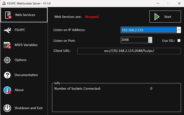
You can use the app on any device in your local network. All you need is a (modern) browser on that device and a working network connection. The tricky part is that network setup. First you need to setup FSUIPC with a local IP-Address instead of 127.0.0.1. To do so, you need to start FSUIPC as administrator and enter the IP address of your Flight Sim Computer in the Web Socket Server. This should be available as the last entry of the IP-Address selectbox. Will probably start with 192.168... Note that IP, as you will need to enter that on the connection tab once you open lxn2.web.app on your tablet or second computer.
At the first try things will most likely not work, as lxn2.web.app is served through an encrypted "ssl"-connection, while the local web socket server cannot provide a similar secure encryption. By default such connections are considered dangerous and therfore blocked by your browser.
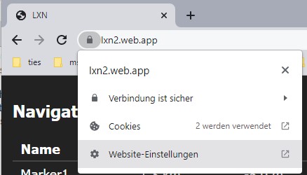
This is a very useful feature of browsers to prevent malicious attacks from evil websites, but since you'll probably trust yourself and the data coming from your MSFS istallation you can specifically allow the browser to make an exception, when displaying lxn2.web.app. To do so, click the little padlock-icon in the adress bar, got to "website settings" and change "incsecure contents" to "allow".
At least that's how it works on Chrome/Windows. Other browsers may use other symbology/terminology. Especially when trying to connect from a mobile device, these settings might be very carefully hidden by the operating system.
Try Google for help and more information.
If you successfully allowed mixed content in your browser and still don't get a connection from your device, you need to check you network settings. There is an abundance of security features, that can possibly block traffic on your local network. It's impossible to tell from a distance, what might be the issue on an individual device or connection. If i had a universal solution to circumvent firewalls or port blocking, i wouldn't play with toy airplanes, but be an international super-hacker stealing that secret porn collection from your hard drive! Oops, i probably shouldn't have mentioned that. :-D
Further from here
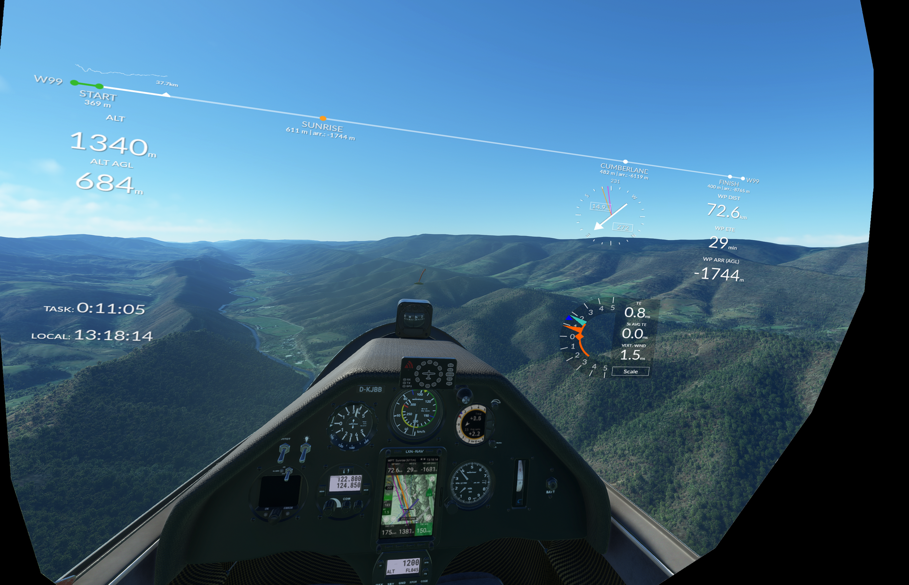
The first comment i got when showin off the very first version was: "useless, i'm only flying in VR". Same is true for people that don't run a second monitor or extra devices. It's definitely a poor idea to alt/tab to a browser view in flight. What's needed is an option to display MSFS and additional nav information at the same time.
Enter: the LXN Ingame Panel. This gives you the option of placing the complete LXN2-App with all feature (minus the map) as a transparent overlay in your cockpit view.